Luochuan loess National Geopark and Chinese Loess Plateau Most Popular China Holiday Adventure
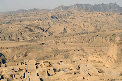
Geological sections of the Quaternary loess form the core part of the Park that exhibit the spectacular views of the erosion surfaces of the loess morphology. As the important landscape in the nature, the loess geomorphic landscape in Chinese Loess Plateau has been concerned widely by the geosciences circles (Guo, 2008, P.107-124 & Xu, 2004, P.1871-1882 & B. Fu, 1994, P.33-40), but as a kind of tourism resource, the loess landscape is ignored up to now (Wu, 2005, P.513-519 & Zhao, 2007, P.95-99). The loess geomorphic landscape includes not only the loess stratum section which is the best Quaternary continental record in the world, but the erosion landscape that the soils are eroded most seriously in the world, and specific loess wonders such as loess tableland ( ‘Yuan’ in chinese), loess ridge (Liang), loess hills (Mao) (Liu T S, 1985, P.1-251), rivers and gorges, which largely attract domestic and foreign tourists.
The White Deer Plateau (here Plateau is named as Yuan in local Chinese, a tableland landform) is the largest plateau near Xi’an city, and its exposed loess stratum completely and systematically records the past environment change (Bloemendal J, 2008, P.152-168 & Zhao J, 2008, P.665-676), which possesses higher scientific and research values, and is the important resource to study the geology and develop the popular science tourism. Because the tourism development emphases of the White Deer Plateau are only limited in the Hundreds Hectares Cheery Garden and the Cetacean Channel at present, so the development of the special and abundant loess tourism resources is still ignored, which not only wastes the resources, but limits the tourism development space of the White Deer Plateau. Therefore, it is very important to strengthen the development of the loess tourism resources in the White Deer Plateau.
According to the feature of loess environment, geographic conditions and traffic advantage, combining the advantages, features and development actuality of the loess landscape on the Loess Plateau, combining with tourists’ intensive requirements for the participation, knowledge and culture of the tourism products, the idea of constructing the loess sculpture garden on the White Deer Plateau is proposed in the article. The visual, lively and abundant loess physiognomy landscape, the loess and environment, and the loess culture full of Chinese characters will be utilized to drive the development of the tourism industry in the White Deer Plateau, promote the advance of the loess culture and create the new mode of geological popular science tourism. And the White Deer Plateau will be constructed as the Chinese loess geological popular science tourism base and the “large tourism plateau” in the area of Xi’an.
The surface of the plateau rises northeast, and descends southwest, and the height differences between the northern plateau and the Bahe River are in 260~350m, and the height differences between the southern plateau and the Chanhe River are in 150~200m. The gullies and streams in the White Deer Plateau mainly include Gaojiagou gully, Shenyusi gully, Wanggou gully and Cetacean stream. The lengths of former three gullies are about 5km, but the length of the Cetacean stream is about 25km.
The tourism resources of the White Deer Plateau are abundant and diversiform, and they include the loess plateau and ravine physiognomy landscape, the graceful water landscapes such as reservoirs, springs and gullies, the woodlands and agricultural landscapes, the literature tourism resource of “White Deer Plain”, the deep historical and cultural tourism resource, the famous Hanwen Baling Mausoleum, Quen Mother Bo Mausoleum, Queen Dou Mausoleum, site of Diqing Camp, the live custom culture resource, and the cave-house sites where villagers lived in early years such as Changchungou gullyl and Sunjiagou gully. But at present, only the Hundreds Hectares Cheery Garden and the Cetacean Channel are developed, and most tourism resources are still in the state of un-development or the state of waiting development, so the development potential of the tourism is very large.


0 comments:
Post a Comment