


Krabi is a southern province on Thailand's Andaman seaboard with perhaps the country's oldest history of continued settlement. After dating stone tools, ancient coloured pictures, beads, pottery and skeletal remains found in the province's many cliffs and caves, it is thought that Krabi has been home to homo sapiens since the period 25,000 - 35,000 B.C. In recorded times it was called the 'Ban Thai Samor', and was one of twelve towns that used, before people were widely literate, the monkey for their standard. At that time, c. 1200 A.D., Krabi was tributary to the Kingdom of Ligor, a city on the Kra Peninsula's east coast better known today as Nakhon Si Thammarat.

At the start of the Rattanakosin period, about 200 years ago, when the capital was finally settled at Bangkok, an elephant kraal was established in Krabi by order of Chao Phraya Nakorn (Noi), the governor of Nakhon Si Thammarat, which was by then a part of the Thai Kingdom. He sent his vizier, the Phra Palad, to oversee this task, which was to ensure a regular supply of elephants for the larger town. So followers many emigrated in the steps of the Phra Palad that soon Krabi had a large community in three different boroughs : Pakasai, Khlong Pon, and Pak Lao. In 1872, King Chulalongkorn graciously elevated these to town status, called Krabi, a word that preserves in its meaning the monkey symbolism of the old standard.

The town's first governor was Luang Thep Sena, though it continued a while as a dependency of Nakhon Si Thammarat. This was changed in 1875, when Krabi was raised to a fourthlevel town in the old system of Thai government. Administrators then reported directly to the central government in Bangkok, and Krabi's history as a unique entity separated from the other provinces, had begun.
During the present reign, the corps of civil servants, the merchants, and the population generally of Krabi and nearby provinces have together organized construction of a royal residence at Laem Hang Nak Cape for presentation to His Majesty the King. This lies thirty kilometers to the west of Krabi Town on the Andaman coast.

Administration
Krabi is divided into eight districts : Amphoe Muang (Krabi Town), Khao Panom, Khlong Thom, Plai Phraya, Ko Lanta, Ao Luk, and Lam Thap and, Nhua Khlong.
Location
Krabi is on the Andaman Sea coast of south-west Thailand, between 7' 30" and 8' 30" north latitude, and 98' 30" and 99' 30" west longitude. Total area is 4,709 square kilometers bounded thus :From Krabi city to nearby provinces
- Phang Nga 86 kms.
- Phuket 176 kms.
- Trang 131 kms.
- Phattalung 193 kms.
- Surat Thani 211 kms.
- Nakhon Si Thammarat 233 kms.
- Satun 276 kms.
From Krabi city to its districts
- Ao Luk 43 kms.
- Plai Phraya 66 kms.
- Khao Panom 39 kms.
- Khlong Thom 42 kms.
- Ko Lanta 103 45 kms.
- Lam Thap 67 kms.
- Nua Khlong 17 kms.
Geography
Krabi's mountainous physical geography is broken by highlands and plains on the mainland.The provincial administration also covers more than 130 islands in the Andaman Sea. Natural forest cover is chiefly mangrove and Cassia trees. Krabi's sandy clay soil conditions are perfect for a variety of agricultural products, including rubber trees, palms, mangos, coconuts, and coffee. The Krabi River flows 5 kilometers through the city and falls into the Andaman at Tambon Pak Nam. There are other streams as well: the Khlong Pakasai, the Khlong Krabi Yai and the Khlong Krabi Noi in the province's highest range of mountains, the Khao Phanom Bencha.
Climate
Weather in Krabi is typically that of the tropical monsoon, providing the province with just two seasons, the hot season from January to April, and the rainy season from May to December. Monsoon winds, which change according to season, blow from the southeast, the southwest, and the northeast. Temperatures range between 16.9 and 37.3 degrees Celsius and the yearly rainfall averages 2,568.5 millimeters.
Tourist Attractions
Railay Beach
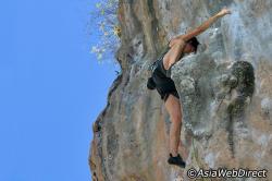 Railay Beach is a small peninsula located between the city of Krabi and Ao Nang. Accessible only by boat due to the high limestone cliffs cutting off mainland access. These cliffs attract rock climbers from all over the world, but the area is also popular due to its beautiful beaches and quiet relaxing atmosphere. Accommodation ranges from inexpensive bungalows popular with backpackers and climbers, to the renowned jet-set resort of Rayavadee. The four main areas of Railay consist of Pranang, West Railay, East Railay and Tonsai, with Tonsai catering more to climbers.
 Krabi’s limestone cliffs are heaven for rock-climbing enthusiasts, who come from all over the globe to take up the challenge of climbing them. Over 650 routes have developed since the late 1980's when Krabi first witnessed the sight of people scaling its craggy mountains. Routes follow limestone crags, steep, pocketed walls, overhangs and hanging stalactites. Some are accessed by boat while others are approached via a jungle walk or by abseiling above the sea.
Khao Khanap Nam
These two hills, roughly 100 meters tall, flank the Krabi River running between them to form a distinctive vista and the town's most prominent landmark. To visit them, take a long-tail boat from Chao Fa Pier. Travel time is just 15 minutes. From there take stairs leading up to caves with stalactites and stalagmites. A large number of human skeletons have been found here. It is theorized that they and the remains of people who came and established a home at Kanab Nam, but were cut off by an inundation and quickly perished.
Tham Sua

Tham Sadet
Tham Sadet is located at Ban Nong Kok, Tambon Sai Thai, 7 kilometres from the town on Highway No. 4034. It is a beautiful cave with stalactites and stalagmites. In 1909 the future King Rama VI visited the cave here, earning it the title "Sadet" indicating the presence of royalty.
Sa Kaeo
Sa kaeo composed of eight small natural swamps in a vast valley of Tambon Khao Thong. This forms part of a which is being turned into recreational area. Sa Kaeo is accessible by the Krabi-Nai Sa route (Highway No. 4034), a distance of 28 kilometres.
Susan Hoi (Fossil Shell Beach)
The shell graveyard at Ban Laem Pho was once a large freshwater swamp, home to a kind of snail. Over eons dating from the Tertiary Age, about 40 million years ago, these snails lived and died by the million, to the extent that the dead snails formed a layer upon which existed the living. Eventually, weather changes precipitated the swamp's disappearance, but by then the layer of fossilized snail shells was forty centimeters thick, resting on ten centimeters of lignite below which is the subsoil. Because of geographic upheaval, this Shelly limestone is now distributed in great broken sheets of impressive magnitude on the seashore at Laem Pho.
Mu Ko Phi Phi National Park
Mu Ko Phi Phi National Park This 2 kilometer long beach is about 18 kilometers north-west of Krabi. It is a scenic beach lined with casuarina trees and is popular among locals especially at weekend. Accommodation at the beach is available. Reservation should be made in advance at the Forestry Department in Bangkok.
Ao Nang
Ao Nang is a large bay with scenic beaches and 83 small islands. Its famous beaches include East Rai Le, West Rai Le, Tham Phra Nang which stretch to the foot of a conspicuously prominent limestone range. Accommodation and other facilities including diving shops, boats for rent and sightseeing by canoe are available. From Ao Nang tourist may hire boats to visit nearby islands of Poda, Thap and Mo which have white sandy beaches, clear water and colorful fishes and coral.
Mu Ko Phi Phi
An archipelago of six islands consists of Ko Phi Phi Don and Ko Phi Phi Le as the major islands. The superb scenery of the islands includes high hills with jutting clifts surrounded by marvelous beaches and emerald sea, hiding underneath a bank of coral reefs and colorful marine life. Places to visit of Mu Ko Phi Phi include :
Ko Phi Phi Don
Ko Phi Phi Don covers a total area of 28 square kilometers. An outstanding attraction is Ao Ton Sai, a vast bay with a curving white sandy beach stretching to a mountain range which reaches into the sea. Beside Ao Ton Sai, there are also othe scenic beaches and bays around the island which can be reached by boat. At
the north end of the island is Laem Tong where a sea gypsy village is located and which is renowned for its underwater natural beauty. Day trip around the island by boat is recommended.
Ko Phi Phi Le
Ko Phi Phi Le An island of steep cliffs, covers a total area of 6.6 square kilometers. Phi Phi Le has several beautiful bays such as Pi Le which reaches into a valley and gives a lake-like scenery. This part of the sea is almost encircled by steep cliffs. To the south of Pi Le is a small bay called Lo Sa Ma which hides in a fold of a steep rock and provides a good spot for snorkeling. Another attraction is Tham Viking, a huge vast and airy cave which is home to a large number of swallows. On the cave wall are ancient paintings of sailing ships similar to those used by ancient Vikings. It takes about 30 minutes to get to Phi Phi Le by boat from Phi Phi Don.
Ko Phai
Ko Phai lies to the north of Phi Phi Don. There are lovely beaches on the north and east sides, and coral gardens spreading to the south.
Ko Yung
Ko Yung also lies to the north of Phi Phi Don. There is a rocky beach on the eastern side, a small beach in a fold of the hill and perfectly preserved coral gardens.


0 comments:
Post a Comment